Wir verwenden Cookies, um die grundlegende Funktionalität unserer Website zu gewährleisten. Mehr Informationen dazu finden Sie in unserer Datenschutzerklärung.
The colored boxes show which forecasts we offer for this region:
MetGIS Light: free to use, weather forecasts maps for large areas, forecast range two days
MetGIS Basic: for private persons, extremely small-scale and detailled weather forecasts, forecast range 7 days
MetGIS Pro: enterprise solution, includes individual forecast areas, parameters and functionalities
The tick (checkmark) on one of the color boxes indicates that you can open this version with a simple click. MetGIS Light can always be used free of charge. MetGIS Basic and MetGIS Pro are available, if you have purchased the product and registered with your access data.
If you encounter on our website www.metgis.com/map a region listing with color boxes of the above kind, this means:
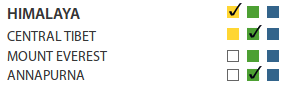
- For Himalaya and Central Tibet all three boxes are filled (yellow, green, blue), i.e. for these forecast regions all three product versions
(MetGIS Light, Basic and Pro) are offered. Concerning Mount Everest and Annapurna, only two color boxes are filled (green and blue), i.e. for these regions
strictly only MetGIS Basic and MetGIS Pro are available.
- The green boxes related to the forecast regions Central Tibet and Annapurna are checkmarked. This means that the currently registered user has bought a MetGIS
Basic license for these areas and can use all functionalities of that product version there. Additionally he has access to the MetGIS Light version for
Himalaya (mind the check-marked yellow box). Since for Mount Everest the MetGIS Light variant is not offered (no yellow box is available) and the user
also has not ordered the MetGIS Basic or Pro version, he has currently no access to any Mount Everest forecasts.

 MetGIS Light: free to use, weather forecasts maps for large areas, forecast range two days
 MetGIS Basic: for private persons, extremely small-scale and detailled weather forecasts, forecast range 7 days
 MetGIS Pro: enterprise solution, includes individual forecast areas, parameters and functionalities